

The EBAR array is operated with support from Strategy AV21 – Dynamic Planet Earth.
Eastern Bohemia · Czechia
EBAR Seismic Array
The EBAR seismic array is a local monitoring array operated by the Institute of Rock Structure and Mechanics of the Czech Academy of Sciences (IRSM CAS) in eastern Bohemia.
It was established to investigate present-day seismicity along the Hronov–Poříčí Fault Zone (HPFZ), a major tectonic structure in northeastern Czechia. This is the second most seismically active region in Bohemia after western Bohemia.
The dense station configuration enables accurate detection and location of weak seismic events and helps distinguish natural earthquakes from anthropogenic sources such as quarry blasts.
- Array operator
- IRSM CAS
- Seismic stations
- 7 EBAR stations
3 regional stations - Complementary measurements
- 4 hydrogeological boreholes
3 GNSS stations
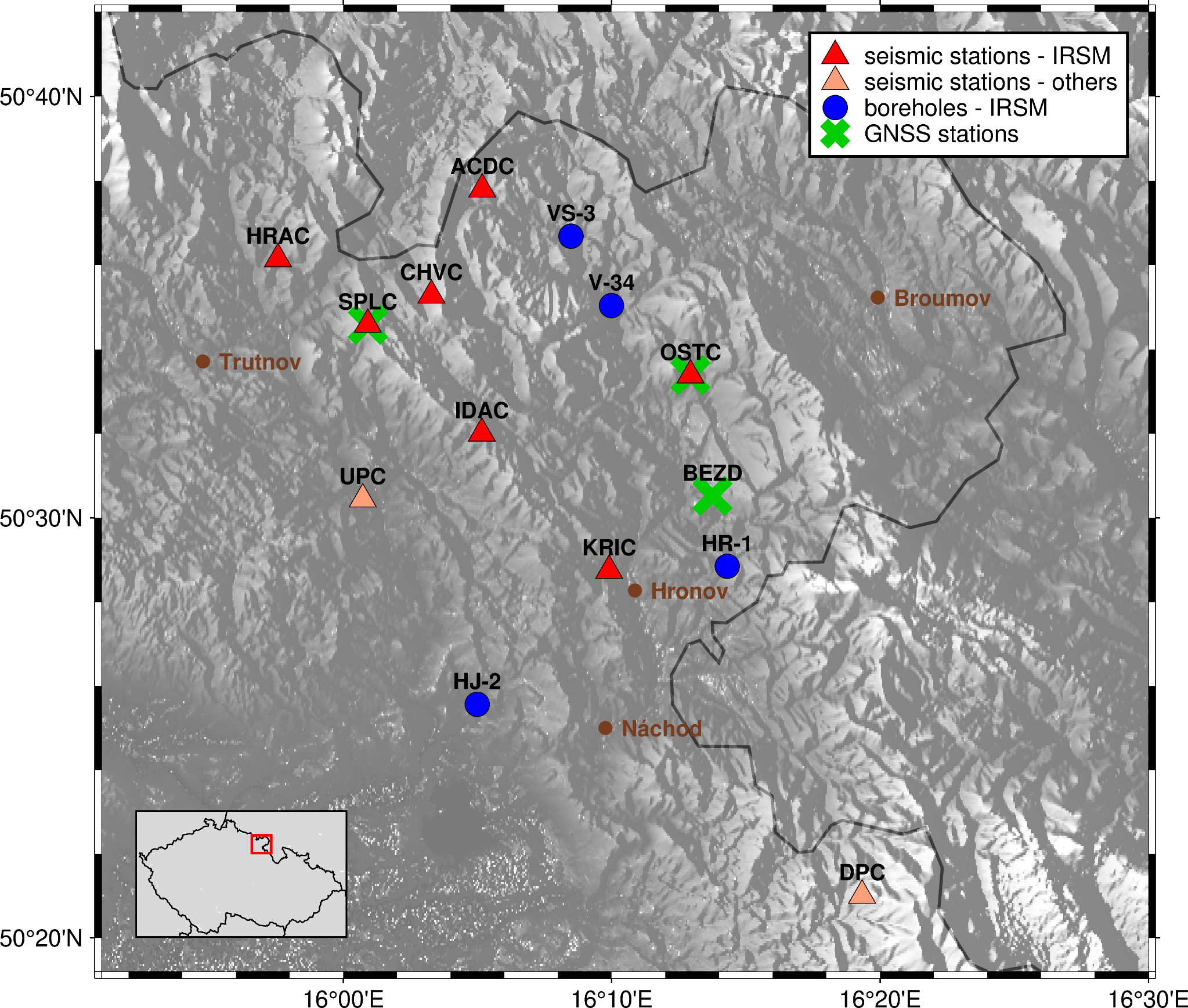
Array map
Seismic monitoring
Seismic stations
The EBAR array comprises seven stations operated by IRSM CAS. Observations are complemented by DPC and UPC, operated by the Institute of Geophysics of the Czech Academy of Sciences as part of the Czech Regional Seismic Network, and by KSP (Książ) in Poland, operated by the Institute of Geophysics, Polish Academy of Sciences, as part of the Polish Seismological Network (PL).
EBAR stations
| Code | Name | Latitude (°N) | Longitude (°E) | Altitude (m) | Operator |
|---|---|---|---|---|---|
| ACDC | Adršpach | 50.63000 | 16.08630 | 653.0 | IRSM CAS |
| HRAC | Hranice | 50.60247 | 15.95945 | 528.0 | IRSM CAS |
| CHVC | Chvaleč | 50.58810 | 16.05470 | 600.0 | IRSM CAS |
| IDAC | Ida - Odolov | 50.53344 | 16.08603 | 410.0 | IRSM CAS |
| KRIC | U Křížku | 50.47913 | 16.16510 | 407.0 | IRSM CAS |
| OSTC | Ostaš | 50.55650 | 16.21560 | 556.0 | IRSM CAS |
| SPLC | Slavětín – pod lesem | 50.57650 | 16.01520 | 642.0 | IRSM CAS |
Complementary regional stations
| Code | Name | Latitude (°N) | Longitude (°E) | Altitude (m) | Network | Operator |
|---|---|---|---|---|---|---|
| DPC | Dobruška/Polom | 50.35020 | 16.32220 | 748.0 | Czech Regional Seismic Network | Institute of Geophysics CAS |
| UPC | Úpice | 50.50740 | 16.01210 | 416.0 | Czech Regional Seismic Network | Institute of Geophysics CAS |
| KSP | Książ | 50.84281 | 16.29311 | 353.0 | Polish Seismological Network (PL) | Institute of Geophysics, Polish Academy of Sciences |
DPC is operated in cooperation with VGHMÚř Dobruška; UPC is operated in cooperation with the Úpice Observatory.
Hydrogeological monitoring
Hydrogeological boreholes
Seismic monitoring is complemented by long-term groundwater-level observations in boreholes close to the HPFZ. These measurements provide additional information on crustal deformation, Earth-tide responses and possible changes in the mechanical and stress conditions of the fault zone.
| Code | Name | Latitude (°N) | Longitude (°E) | Altitude (m) | Depth (m) | Operator |
|---|---|---|---|---|---|---|
| VS-3 | Adršpach (Bučnice) | 50.61142 | 16.14138 | 489.0 | 305 | IRSM CAS |
| V-34 | Teplice nad Metují | 50.58399 | 16.16652 | 523.0 | 281 | IRSM CAS |
| HR-1 | Žďárky (Sedmákovice) | 50.48079 | 16.23843 | 440.0 | 150 | IRSM CAS |
| HJ-2 | Třtice (Studnice) | 50.42608 | 16.08315 | 309.0 | 35 | IRSM CAS |
Complementary measurements
GNSS stations
Complementary measurements include observations from three Global Navigation Satellite System (GNSS) stations operated by IRSM CAS: BEZD, OSTA and SLAV.
| Code | Name | Latitude (°N) | Longitude (°E) | Altitude (m) | Operator |
|---|---|---|---|---|---|
| BEZD | Bezděkov | 50.50870 | 16.22926 | 539.0 | IRSM CAS |
| OSTA | Ostaš | 50.55649 | 16.21559 | 606.0 | IRSM CAS |
| SLAV | Slavětín | 50.57647 | 16.01525 | 690.0 | IRSM CAS |
Geological setting
Hronov–Poříčí Fault Zone
The HPFZ is a 40–50 km long fault system extending across the Broumov Highlands, Police Basin and adjacent areas. Earthquakes in this region are shallow, typically occurring at depths of less than 15 km.
Historical seismicity
The strongest documented historical event was the Hronov earthquake of 10 January 1901, with a moment magnitude of Mw 4.8 and a maximum intensity of VII. It caused building damage and widespread changes in groundwater levels.
Patronage
Under the patronage of the City of Trutnov
The EBAR seismic array operates under the patronage of the City of Trutnov.
City of Trutnov website