Monitoring |
Landslide detachment plane monitoring around the incipient San Andrés megalandslide on El Hierro began in 2013. Three monitoring points were each instrumented with a specially designed extensometer called a TM-71 (Košt’ák 1969). These take advantage of the moiré phenomenon of optical inference as generated by concentric spirals and parallel lines to measure extremely small movements (Nishijima & Oster 1964). The concentric spirals are able to measure the amount of relative displacement across a discontinuity in three Cartesian coordinates with a precision of better than ± 0.007 mm while the parallel lines are able to measure the amount of relative horizontal and vertical angular rotation between the two opposing sidewalls with a precision of better than ± 0.00016 rad (Martà et al. 2013).
Detachment plane monitoring point HIE1 is located at a depth of about 900 m below the surface in Tijirote Gallery across a discontinuity whose dip and dip direction are 60°/114°. Monitoring point HIE2 is located across a discontinuity near the surface whose dip and dip direction are 75°/140° while monitoring point HIE3 is located across a discontinuity near the surface whose dip and dip direction are 89°/189°. Each of the monitored detachment planes preserve slickensides while the plane in Tijirote Gallery is also filled with gouge.
|
| |
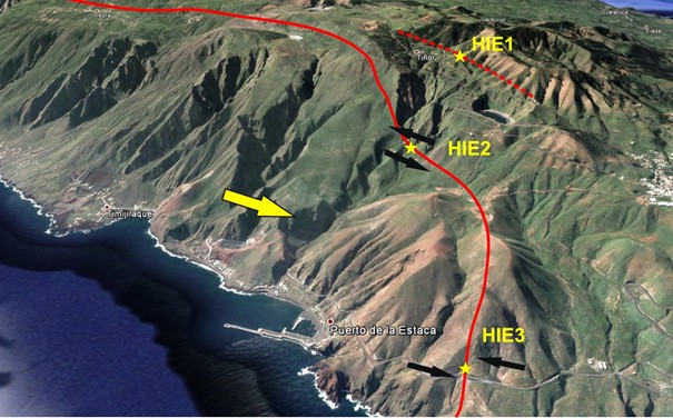
3D view of the san Andrés megalandslide showing the location of the monitoring points and interpretation of the movement. Adopted from Klimeš et al. (2016). |
| |
|
|
| |


