Study Area |
El Hierro represents the smallest and youngest of the Canary Isles and is located about 100 km from the northwestern coast of Africa. Four of the megalandslides that have taken place around the Canary Isles have taken place on El Hierro. These have given the island its conspicuous triaxial shape and a number of head and lateral scars are still clearly visible in the topography. Moreover, closer inspection shows that two types of landslide can be distinguished, debris avalanches and rockslides. Three of the four megalandslides are represented by catastrophic debris avalanches (El Golfo, El JulÃĄn, Las Playas) while one is represented by an aborted rockslide (San AndrÃĐs). These have reduced the volume of the island by a total of 450 km3 (Gee et al. 2001).
The Canary Isles are believed to be underlain by a mantle plume centered under La Palma and El Hierro (Carracedo et al. 1998). More than twenty megalandslides are known to have occurred in this area during the past 200â300 ka and these have reduced the total volume of the islands by approximately 25 %. From October 2011 to March 2012 a series of eruptions began along a volcanic rift close to the island of El Hierro. These were accompanied by protracted seismicity which continues to the present day. Since the onset of volcanism more than 22,000 earthquakes have been recorded with local magnitudes of up to 5.1. This geodynamic instability has greatly enhanced the chances of initiating another megalandslide and raises urgent questions about the dynamic behaviour of incipient megalandslides. The detachment planes of the San AndrÃĐs Landslide are thought to be particularly prone to reactivation. Carracedo et al. (1999) suggested that these planes are inactive although Day et al. (1997) recognised that a giant lateral collapse hereabouts may occur with almost no warning and only limited evidence of precursory deformation. Reactivation would have severe consequences for those living along this densely populated and economically important coastline so it is clear that megalandslides represent a major geological hazard for both El Hierro and the other Canary Isles (Krastel et al. 2001). Furthermore, an associated tsunami may affect a wide area including northwestern Africa, western Europe, and the eastern Americas. Researchers from the Institute of Rock Structure & Mechanics began monitoring landslide detachment planes around the incipient San AndrÃĐs megalandslide on El Hierro in 2013. This project continues that research by building a new automated deformation monitoring system.
|
| |
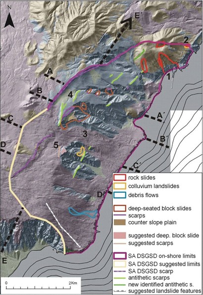
Delimitations of San AndrÃĐs megalandslide (SA DSGSD). Adopted from KlimeÅĄ et al. (2016). |
| |


