Department of Engineering Geology analyse and interpret the dangerous geodynamical phenomena and processes, which affect the behaviour, development and stability of the rock environment in their natural deposition in the Earth’s crust. These phenomena are linked with exogenous processes, such as slope deformations and weathering, as well as endogenous processes, such as tectonics, fault movements and gas emanations. Special attention is paid to the development of reliable and accurate methods of monitoring of slope and tectonic processes and predicting their development and occurrence in space and time.
1. Landslides In the landslide research, the team concentrates on multidisciplinary studies of various types of slope processes, ranging from deep-seated landslides through debris flows to rockfalls, with our study sites spread both in the Czech Republic and worldwide (Peru, Svalbard, Kyrgyzstan, Austria, Canary Is., etc.). In our work we apply innovative methods and approaches, including geophysical, geodetical, remote sensing and monitoring techniques, combined with various environmental data to assess the landslide hazard and to propose suitable mitigation measures. We therefore often work as consultants for both state institutions and private enterprises.
2. Tectonics The research focus of the team is the monitoring of the slow, yet omnipresent aseismic creep along tectonic faults. These movements, with velocity varying from centimetres in highly active areas to less than 0.01 millimetres/year in less active regions, accommodate part of the tectonic stress and thus their understanding is one of the crucial conditions for the development of forecasting of the earthquakes, the ultimate goal of tectonic and seismic research. Our dedicated network for the fault monitoring TecNet covers many countries in Europe and the World. Recently, we have advanced towards calculation of current stress field and its changes, based on our direct measurements on tectonic faults.
3. Monitoring and instruments development Since 1970ies, the department team is very active in the development and applications of monitoring devices. Our specialty is a very precise 3D dilatometer TM-71, continuously developed form the first optical-mechanical models towards the current device with better precision, automatic reading, data transfer and processing. The improvements are partly aided by in-house design and production of new parts using 3D printing technology. We also test and apply the cutting-edge technologies and methods like TLS (terrestrial laser scanner or LiDAR), modern geophysical methods or UAVs (unmanned aerial vehicles or drones).
academic cooperation - project: Tectonic activity of the significant karst systems (development correlation of the Central Europe and Mediterranean area)
The EU TecNet monitoring network provides very precise measurements of tectonic creep, using a series of crack gauges known as TM-71s and GPS measurement.
Project: "Multi-disciplinary study of the processes in the sandstone outcrops: a new approach to research and interpretation of selected sandstone forms" (GA13-28040S, 2013-2015), Investigator: Mgr. Jana Schweigstillova, Ph.D.,
cooperation Dr. A. Mayo
The Central Geological Survey (CGS), under the Ministry of Economic Affairs (MOEA)
Project: The EU TecNet monitoring network provides very precise measurements of tectonic creep, using a series of crack gauges known as TM-71s and GPS measurement.
International cooperation without grant (Articles) 2013:
Dr. Edmundo Norabuena - Common geodynamic laboratory and create articles.
Dr. Mauro Rossi, CNR-IRPI, Perugia, Italy - article on the stability of slopes in the vicinity of Machu Picchu.
Project: The EU TecNet monitoring network provides very precise measurements of tectonic creep, using a series of crack gauges known as TM-71s and GPS measurement.
Localities: Colfiorito, Norcia, Matinatta (Gargano), Central and South Apennine Mountains
Mega-landslides: imminent hazard or sleeping giants? Monitoring the landslide hazard related to ongoing volcanic activity around El Hierro, Canary Islands, Spain (Grant No.: W244-12, 2012-2013)
Investigators:
Dr. J. Yepes, University of Gran Canaria,
Dr. I. Galindo Jimenez, IGME,
Dr. S. Metliditis, IGN,
Mgr. Jan Blahut, Ph.D. and RNDr. Jan Klimes, Ph.D.
"Contact the Western Carpathians and the Bohemian Massif from the perspective of tiny tectonics in cliff zone based on the measurement and interpretation of results from natural underground space and possible correlations in the region" - Inter-Academy cooperation, 2012-2014, Dr. Joseph Vozar, Dr. Milos Briestenský, Ph.D.
National Archaeological Park of
Machup icchu, Peru
Peru
Results
Contactless laser positioning system for tracking three-dimensional kinematic behaviour of rock slope fractures and active faults tested on a large rockslide in the Western Alps
2025
Discontinuities within large rock slope failures are able to provide critical insights into the prevailing stress and strain regimes governing the behaviour of these unstable rock masses. To capture the true displacement vectors—essential for accurate failure mode characterisation and computation of the near-surface stress state—information about their kinematic behaviour must be obtained in three dimensions. Yet only a few extensometers have been designed for this purpose. This technical note presents an innovative contactless laser positioning system that employs a triangulation approach to generate three-dimensional records of fault and fracture behaviour in near real time. The positioning system comprises a sensing unit—a pair of laser modules, a digital camera, and a customised target—and a control unit together with a processing unit hosted on a remote server. Images of the target are acquired at regular intervals and transmitted to the server, where a semiautomated image processing protocol transforms the beam patterns into accurate three-dimensional measurements. Its accuracy is characterised by a maximal standard deviation in a single-axis measurement of 0.04 mm, and its precision is estimated to be better than 0.02 mm. Two of these devices have been tested on a large rock slope failure located on the eastern flanks of the Aiguilles Rouges in south-eastern France. Although the site posed a range of technical and logistical challenges, it is clear that the laser positioning system is capable of detecting complex kinematic fracture behaviour, opening the door for its integration into more comprehensive landslide monitoring programs.
Publication: Baroň I., Trčka T., Čejka J., Škarvada P., Dolejška D., Vassallo R., Metral L., Rowberry M., Balek J., Hartvich F. (2025). Contactless laser positioning system for tracking three-dimensional kinematic behaviour of rock slope fractures and active faults tested on a large rockslide in the Western Alps. Landslides. https://doi.org/10.1007/s10346-025-02648-y
Image
Complete historical chronology of complex landslide movements? Improving the tree-ring based results using multidisciplinary approaches
2025
Publication: Šilhán K, Balek J, Klimeš J, Blahůt J, Hartvich F, Raška P, Riezner J, Šťastný M (2025). Complete historical chronology of complex landslide movements? Improving the tree-ring based results using multidisciplinary approaches. CATENA 252, 108877. https://doi.org/10.1016/j.catena.2025.108877
Fault mirrors in the process zone of a seismogenic fault (Karawanks, Eastern Alps)
2025
Publication: Koppensteiner S.J., Bauer H., Grasemann B., Plan L., Baroň I. (2025). Fault mirrors in the process zone of a seismogenic fault (Karawanks, Eastern Alps). Austrian Journal of Earth Sciences 118, No.1–Sciendo, 115–132. https://doi.org/10.17738/ajes.2025.0006
Rockfall in orthogonally jointed sandstone: a multi-instrumental study of a pillar collapse
2025
Publication: Hartvich F.,Duszyński F., Tábořík P.,Jancewicz K., Adamovič A., Bartz W. (2025). Rockfall in orthogonally jointed sandstone: a multi-instrumental study of a pillar collapse. Bull Eng Geol Environ 84, 513. https://doi.org/10.1007/s10064-025-04526-2
Searching for muons in caves
2025
Publication: Mikluš V., Trčka T., Rowberry M., Rogerson M. (2025). Searching for muons in caves. Cave Radio and Electronics Group Journal 129, 22–24. https://www.researchgate.net/publication/396463607_
Chapter thirteen - Building landslide inventory with LiDAR data and deep learning
2025
Publication: Létal A, Klimeš J, Şandric I (2025). Chapter 13 – Building landslide inventory with LiDAR data and deep learning.Earth Observation Applications to Landslide Mapping, Monitoring and Modeling, 297–311. https://doi.org/10.1016/B978-0-12-823868-4.00014-3
Landslides in the glaciated mountains of the Cordillera Blanca, Peru—types, spatial distribution, and conditioning factors
2024
Publication: Klimeš, J., Kilnar, K., Kopačková-Strnadová, V., Pánek, T., McColl, S. (2024) Landslides in the glaciated mountains of the Cordillera Blanca, Peru – types, spatial distribution and conditioning factors. Landslides. https://doi.org/10.1007/s10346-024-02387-6
Long-term movement activity and internal structure of deep-seated landslide by using dendrochronology analysis and electric resistivity tomography in flysch rocks, Carpathians, Czech Republic
2024
Publication: Klimeš, J., Hartvich, F., Šilhán, K. (2024) Long-term movement activity and internal structure of deep-seated landslide by using dendrochronology analysis and electric resistivity tomography in flysch rocks, Carpathians, Czech Republic. Landslides. https://doi.org/10.1007/s10346-024-02330-9
Source area morphometry and high depletion rate of landslides may indicate their coseismic origin
2024
Ancient coseismic landslides indicate prehistoric earthquakes and may also be a measure of their intensity. Their identification in the landscape remains, however, challenging. We used field geologic observations of source areas of recent rainfall-induced and earthquake-induced landslides to define a morphometric index that can distinguish between these two types of triggers...
Publication: Baroň, I., Jelének, J., Klimeš, J., Dong, J-J., Melichar, R., Šutjak, M., Chen, Y., Yang, C-M., Zhang, E-L., Méndez, J., Tseng, C-H., Hartvich, F., Blahůt, J., Nguyễn, T-T., Kociánová, L., Bárta, F., Dušek, V., Kycl,P. (2024) Source area morphometry and high depletion rate of landslides may indicate their coseismic origin. Engineering Geology. 330: 107424. https://doi.org/10.1016/j.enggeo.2024.107424.
Image
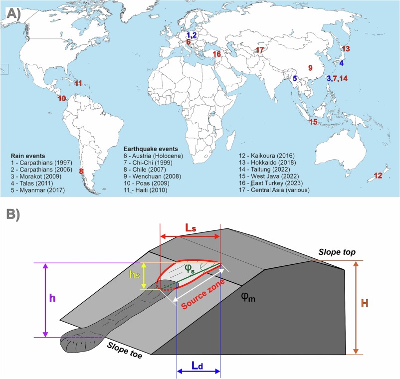
Fig.: General inputs of the study: (A) Overview of the analyzed lerainfall and earthquake landslide events, (B) Schematic model showing the input parameters and morphometric characteristics of landslides´ source zones for calculating the Index of Potential Trigger (IPT). The depletion index Id (Eq. 1) is calculated based on the length of the depleted part (Ld) and the length of the whole source area (Ls), while the source area angle (φS) that is assumed to be much lower at the coseismic slope failures than the host material friction angle (φm) can be calculated from the source area height (hs) and Ls. Relative slope height (Hrel, Eq. 2) is the ratio between landslide scarp top height above the slope toe (h) and the entire slope height, i.e., the elevation difference between the ridge/slope top, and the valley floor (H).
The effect of tree growth disturbances inertia on dendrogeomorphic spatio-temporal analysis of landslides: A case study.
2023
Publication: Šilhán K., Fabiánová A., Klimeš J., Tábořík P., Hartvich F., Blahůt J. (2023): The effect of tree growth disturbances inertia on dendrogeomorphic spatio-temporal analysis of landslides: A case study. Catena 235, 107678. doi.org/10.1016/j.catena.2023.107678
Rock Surface Strain In Situ Monitoring Affected by Temperature Changes at the Požáry Field Lab (Czechia)
2023
A resistive strain gauge method for quantifying rock outcrop surface deformation directly in the field has been verified. An experiment was carried out to apply low cost resistive strain gauges directly to the rock surface. Continuous measurements were then taken over a period of approximately 6 months. The data was then analysed to determine the effect of temperature on the performance of different types of strain gage connection. A high, even theoretical, accuracy of the method was found, but also the need to process the results taking into account the significant influence of temperature on the measurement outputs. Publication: Racek O., Balek J., Loche M., Vích D., Blahůt J. (2023): Rock Surface Strain In Situ Monitoring Affected by Temperature Changes at the Požáry Field Lab (Czechia). Sensors 23(4): 2237. doi.org/10.3390/s23042237
Image
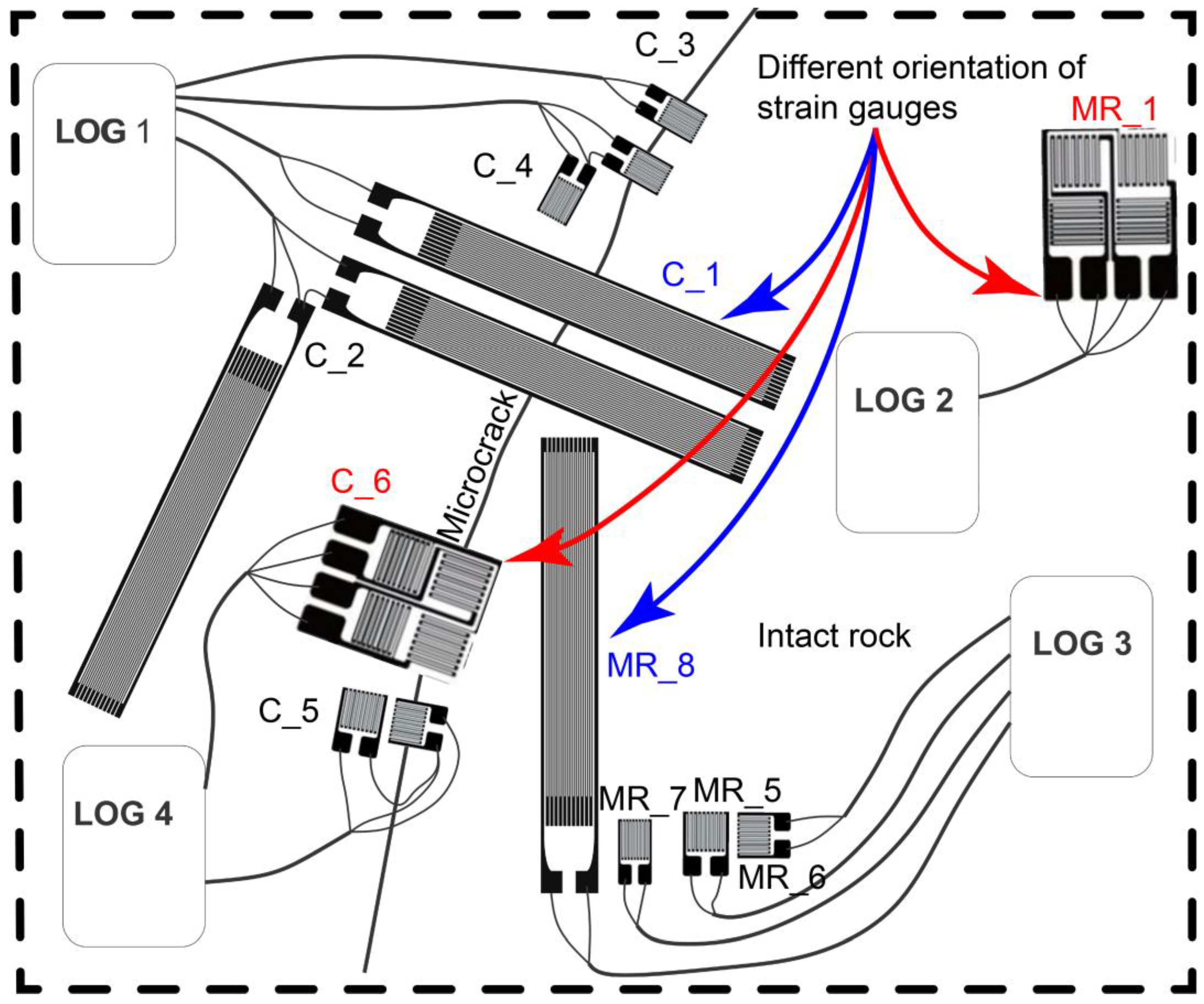
Fig. Sketch of strain gauge configurations. The figure shows the location of the instruments and the detection of both intact rock and microcrack. The configurations of instruments are presented with their different shapes and orientations (red and blue color) for testing possible distinct behavior under temperature changes.
Rate-dependency of residual shear strength of soils: implications for landslide evolution
2023
Publication: Duque, J., Loche, M., & Scaringi, G. (2023). Rate-dependency of residual shear strength of soils: implications for landslide evolution. Géotechnique Letters, 13(2),1-8. https://doi.org/10.1680/jgele.23.00004
New Insights into the Internal Structures and Geotechnical Rock Properties of the Giant San Andrés Landslide, El Hierro Island, Spain
2023
The San Andrés landslide on El Hierro (Canary Islands) represents a rare opportunity to study an incipient volcanic island flank collapse with an extensive onshore part. The presented research improves the knowledge of the internal structure and rock characteristics of a mega-landslide before its complete failure. The onshore geophysical investigations helped detect the possible San Andrés landslide sliding surfaces at depths between 320 m and 420 m, with a rather planar geometry and they also revealed that rocks inside and outside of the landslide had similar properties which suggests that the previous fast movements of the landslide did not affect the bulk properties of the displaced rocks. Publication: Klimeš, J.; Hussain, Y.; Mreyen, A.-S.; Cauchie, L.; Schlögel, R.; Piroton, V.; Petružálek, M.; Blahůt, J.; René, M.; Meletlidis, S.; Havenith, H.-B. (2023) New Insights into the Internal Structures and Geotechnical Rock Properties of the Giant San Andrés Landslide, El Hierro Island, Spain. Remote Sens., 15, 1627. https://doi.org/10.3390/rs15061627
Image
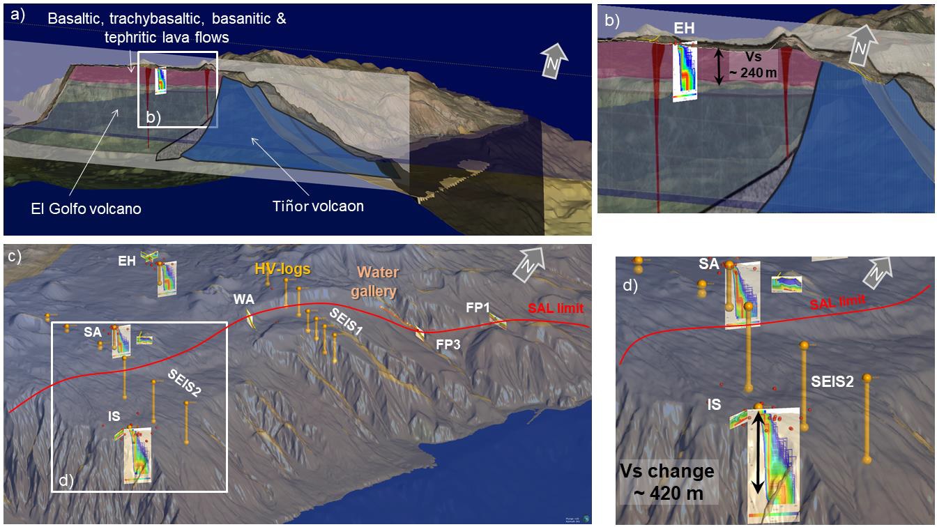
Fig. 3D geomodel of the studied El Hierro. (a) The central part of the SAL with inserted geological cross-section and geophysical results with the detailed view in the inset (b); (c) view of the SW part of the San Andrés landslide with the results of the geophysical measurements and detailed view in the inset (d).
Deformation of columnar calcite within flowstone speleothem
2023
Publication: Mitrovic-Woodell, I., Tesei, T., Plan, L., Habler, G., Baroň, I., Grasemann, B. (2023): Deformation of columnar calcite within flowstone speleothem. - Journal of Structural Geology 174 (2023), 16 pp.104924. https://doi.org/10.1016/j.jsg.2023.104924
Long-term landslide impacts and adaptive responses in rural communities: Using historical cases to validate the cumulative causation approach
2023
Publication: Raška, P., Riezner, J., Bíl, M., Klimeš J. (2023) Long-term landslide impacts and adaptive responses in rural communities: Using historical cases to validate the cumulative causation approach. International Journal of Disaster Risk Reduction, 93, https://doi.org/10.1016/j.ijdrr.2023.103748
Portable muon detectors tested at the British Cave Science Centre
2023
Publication: Rowberry, M., Trčka, T., Mikluš, V., 2023. Portable muon detectors tested at the British Cave Science Centre. Cave and Karst Science, v. 50 (3), pp113-118.
Anatomical growth response of Fagus sylvatica L. to landslide movements
2023
Publication: Šilhán, K., Balek, J., Hartvich, F., Klimeš, J., Blahůt, J., Hampel, F., 2023. Anatomical growth response of Fagus sylvatica L. to landslide movements. Science of the Total Environment 867, 161554. http://dx.doi.org/10.1016/j.scitotenv.2023.161554
Application of novel ensemble models to improve landslide susceptibility mapping reliability
2023
Publication: Tong, Z. L., Guan, Q. T., Arabameri, A., Loche, M., & Scaringi, G. (2023). Application of novel ensemble models to improve landslide susceptibility mapping reliability. Bulletin of Engineering Geology and the Environment, 82(8), 309. https://doi.org/10.1007/s10064-023-03328-8
Evaporation rate from surfaces of various granular rocks: Comparison of measured and calculated values
2023
Publication: Slavík M, Bruthans J, Schweigstillová J (2023) Evaporation rate from surfaces of various granular rocks: Comparison of measured and calculated values. Science of the Total Environment, 856(2):159114. DOI: 10.1016/j.scitotenv.2022.15911
A Decade of Monitoring and Research on the San Andrés Megalandslide on El Hierro, Canary Islands, Spain
2023
Publication: Blahůt J, Klimeš J, Meletlidis S, Balek J, Rowberry M, Baroň (2023):A Decade of monitoring and research on the San Andrés megalandslide on El Hierro, Canary Islands, Spain. Advances in Natural Hazards and Volcanic Risks: Shaping a Sustainable Future, Proceedings of the 3rd International Workshop on Natural Hazards (NATHAZ’22), Terceira Island—Azores 2022, Springer ASTI Series. First Online: 21 April 2023
Rock Mass Characterization and Rockfall Monitoring: Traditional Approaches
2023
Publication: Racek O, Blahůt J (2023):Rock Mass Characterization and Rockfall Monitoring: Traditional Approaches. In Thambidurai P, Singh TN (eds) Landslides: Detection, Prediction and Monitoring – Chapter, pp 39–69, First Online: 03 March 2023, DOI: 10.1007/978-3-031-23859-8_2
Investigating the Potential of Infrared Thermography to Inform on Physical and Mechanical Properties of Soils for Geotechnical Engineering
2022
Publication: Loche M, Scaringi G, Blahůt J, Hartvich F (2022) Investigating the Potential of Infrared Thermography to Inform on Physical and Mechanical Properties of Soils for Geotechnical Engineering. Remote Sensing. 14(16):4067. DOI: 10.3390/rs14164067
Monospecific mass associations of Anaconularia anomala (Cnidaria, Scyphozoa) from the Upper Ordovician of the Czech Republic: sedimentological and palaeobiological significance
2022
Publication: Bruthansová J, Bruthans J, Van Iten H, Rak Š, Schweigstillová J (2022) Monospecific mass associations of Anaconularia anomala (Cnidaria, Scyphozoa) from the Upper Ordovician of the Czech Republic: sedimentological and palaeobiological significance. Lethaia 55(2):1–18. DOI: 10.18261/let.55.2.7
Three large prehistoric earthquakes in the Eastern Alps evidenced by cave rupture and speleothem damage
2022
Publication: Baroň I, Plan L, Grasemann B, Melichar R, Mitrović-Woodell I, Rowberry M , Scholz D (2022): Three large prehistoric earthquakes in the Eastern Alps evidenced by cave rupture and speleothem damage. Geomorphology 408. DOI: 10.1016/j.geomorph.2022.108242
Co-seismic deformation of the 2017 Mw 6.6 Bodrum–Kos earthquake in speleothems of Korakia Cave (Pserimos, Dodecanese, Greece)
2022
Publication: Grasemann B, Plan L, Baroň I , Scholz D (2022): Co-seismic deformation of the 2017 Mw 6.6 Bodrum–Kos earthquake in speleothems of Korakia Cave (Pserimos, Dodecanese, Greece). Geomorphology 402: DOI: 10.1016/j.geomorph.2022.108137
Three-Dimensional Engineering Geological Model and Its Applications for a Landslide Site: Combination of Grid- and Vector-Based Methods
2022
Publication: Nguyễn T-T, Dong JJ, Tseng C-H, Baroň I , Chen C-V, Pai C-C (2022): Three-Dimensional Engineering Geological Model and Its Applications for a Landslide Site: Combination of Grid- and Vector-Based Methods. Water 2022, 14(19): 2941. 10.3390/w14192941
Post-Miocene tectonics of the Northern Calcareous Alps
2022
Publication: Szczygieł J, Baroň I, Melichar R, Plan L, Mitrović-Woodell I, Kaminsky E, Scholz D, Grasemann B (2022): Post-Miocene tectonics of the Northern Calcareous Alps. Scientific Reportsvolume 12, Article number: 17730 (2022) DOI: doi.org/10.1038/s41598-022-22737-5 Cite this article
Differentiating between artificial and natural sources of electromagnetic radiation at a seismogenic fault
2022
Publication: Baroň I , Koktavý P, Trčka T, Rowberry M, Stemberk J, Balek J, Plan L, Melichar R, Diendorfer G, Macků R, Škarvada P, (2022) : Differentiating between artificial and natural sources of electromagnetic radiation at a seismogenic fault. Engineering Geology 311(1–7):106912, DOI:10.1016/j.enggeo.2022.106912
Tools for the efficient analysis of surface waves from active and passive seismic data: exploring an NE-Italy perilagoon area with significant lateral variations
2022
Publication: Dal Moro G, Stemberk J (2022) Tools for the efficient analysis of surface waves from active and passive seismic data: exploring an NE-Italy perilagoon area with significant lateral variations. Earth, Planets and Spacevolume 74, Article number: 140 (2022) Cite this article. DOI: 10.1186/s40623-022-01698-z
Application of fractal and multifractal analysis on Blue Nile drainage patterns in the morphostructural analysis of the Ethiopian highlands, Ethiopia
2022
Publication: Kusák M (2022) Application of fractal and multifractal analysis on Blue Nile drainage patterns in the morphostructural analysis of the Ethiopian highlands, Ethiopia. Progress in Physical Geography: Earth and Environment, Volume 46, Issue 3, 357–370. DOI: 10.1177/03091333211059419
Atmospheric pressure anomalies at the British Cave Science Centre triggered by catastrophic volcanic eruption in Tonga on 15 January 2022
2022
Publication: Rowberry M , Gunn J (2022) Atmospheric pressure anomalies at the British Cave Science Centre triggered by catastrophic volcanic eruption in Tonga on 15 January 2022. Cave & Karst Science 49: 14-18. www.researchgate.net/publication
A global database of giant landslides on volcanic islands
2022
Publication: Rowberry M, Klimeš J, Blahůt J, Balek J, Kusák M (2022) A global database of giant landslides on volcanic islands. Progress in Landslide Research and Technology, Volume 1, Issue 1. Springer, 9783031169007. 10.1007/978-3-031-16898-7_22
Exploring the impact of tourists on cave air temperatures: a Covid-19 case study from Poole’s Cavern, Derbyshire, UK
2021
Publication: Gunn J, Rowberry M , Smith A (2021) Exploring the impact of tourists on cave air temperatures: a Covid-19 case study from Poole’s Cavern, Derbyshire, UK. Cave & Karst Science 48: 121-128. www.researchgate.net/publication